Los Angeles Times Google Map of California Fires
Every day it seems like someone else is using Google Maps for some interesting application, and today’s yet another example. The LA Times has put together a special map of the fires raging in California:
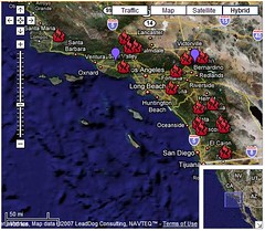
(click to enlarge) or (pan/zoom map)
Share-able online mapping systems like Google Maps have really empowered people to easily use geographic data in extraordinary ways. While news organizations have long slapped together maps of this sort of thing, it really is a paradigm shift to have it updated by the minute and the hour. For the people in those areas or from evacuated areas, this sort of thing is likely extremely useful and valuable.
Over 200,000 people have been told to evacuate their homes in California as the wildfires have been burning out of control. See the current stories here.
Clicking on any of the little flame icons gives updated stats about the particulars of that specific fire.
Is it useful or popular? The map has been viewed nearly 200,000 times already. UPDATE: just within the ten minutes it took me to write this, the map views have increased by 10k! Obviously the map news is quite timely, and with the front-page status of the story the map views will continue to rise rapidly.
The LA Times is using a few different maps to provide detailed information, which can be seen if you click through to the articles.
Kudos to both Google Maps and the L.A. Times.
Possible Related Posts
Posted by Chris of Silvery on 10/22/2007
Permalink | |  Print
| Trackback | Comments Off on Los Angeles Times Google Map of California Fires | Comments RSS
Print
| Trackback | Comments Off on Los Angeles Times Google Map of California Fires | Comments RSS
Filed under: Maps California-Fires, Google-Maps, LA-Wildfires, Los-Angeles-Fires, Los-Angeles-Times, Wildfires


No comments for Los Angeles Times Google Map of California Fires
No comments yet.
Sorry, the comment form is closed at this time.