Google Maps Now Displaying Buildings in 3D
In some major metro areas, Google Maps has quietly begun displaying 3D building wireframes, visible when you’ve zoomed into the more close-up street level views. Here’s the Empire State Building:
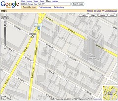
[Google 3D Map of Empire State Building]
The 3D building shapes are apparently adopted from Google Earth, indicating further possible convergence may be on the horizon between the related Google projects.
Possible Related Posts
Posted by Chris of Silvery on 05/09/2007
Permalink | |  Print
| Trackback | Comments Off on Google Maps Now Displaying Buildings in 3D | Comments RSS
Print
| Trackback | Comments Off on Google Maps Now Displaying Buildings in 3D | Comments RSS
Filed under: Google, Local Search, Maps 3D, 3D-Maps, Google-Maps, Local Search

