Town Creates Smiley Face in Google Maps
Saw this interesting thing on Slashdot today:

Apparently this Russian town got a crowd of people to don yellow slickers and stand in a large smiley face pattern so that Google Earth and Google Maps could capture them in their next update.
Trick is, the Google Map screen-grab appears to be a very obvious hoax by a blogger dubbed “Heiner Wolf“. According to these photos, people really did turn out to form the smiley face — I would guess as part of a radio station promotion. But this blogger transposed the people onto the Google Maps image of the area. Lame!
There are plenty of instances of messages appearing in Google Maps pics, if you want to see real ones: examples of roof ads, cool things in Google Maps, marriage proposals, and the infamous Swastika Building.
Possible Related Posts
Posted by Chris of Silvery on 09/25/2008
Permalink | |  Print
| Trackback | Comments (0) | Comments RSS
Print
| Trackback | Comments (0) | Comments RSS
Filed under: Google, Maps aerial-images, Google-Maps, hoaxes, Satellite-Images
Where’s Waldo in Google Earth
In a very clever bit of marketing, Canadian artist Melanie Coles has created a large rooftop image of the iconic character found in the popular Where’s Waldo? book series.
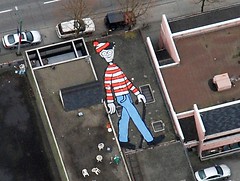
The image is located somewhere in Vancouver, British Columbia, and was created with the specific intention of being findable via Google Earth (warning, I have the location pinpointed in a link and geocoordinates at the end of this post). It will be a while before Waldo can be found in Google Earth (or in Google Maps, Yahoo! Maps, or MS Live Search Maps, for that matter), because there is a time lag in between when satellite images and aerial photos get updated in those services — so, it could be six months to a year before the image is really findable and viewable online.
The image was created as a demonstration of a viral game for Coles’ graduation art project at the Emily Carr Institute. Her blog statement on the project says: (more…)
Possible Related Posts
Posted by Chris of Silvery on 04/14/2008
Permalink | | Print
| Trackback | Comments Off on Where’s Waldo in Google Earth | Comments RSS
Filed under: Google, Maps, News aerial-photos, Google-Earth, Google-Maps, Maps, Mapvertising, Roofvertising, Satellite-Images, Viral-Marketing, Where's Waldo
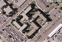
Google Maps forces Navy to redesign swastika building
Quite some time back, I came across this Swastika-shaped building via Google Maps, and posted the screengrab in my Flickr account. Since then, it became one of my most popular Flickr pictures, since strange stuff like this can become quickly viral. Loads of people (16,000+) have viewed the photo’s page, and then various journalists contacted me and posted the photo on news stories in Europe and elsewhere. Here it is:
(click to view swastika photo profile page)
I researched the building and found it was a Navy building, apparently built unintentionally in the shape of a Nazi Swastika in California. This was built way before people anticipated the general public would be viewing buildings from the sky all that much, but now the easy accessibility of viewing satellite pics from Google Maps, Yahoo! Maps, Mapquest, Microsoft Live Maps, and other utilities have made birds-eye-viewing all too common. I photo-blogged the info I researched on the Flickr page, and quite a few people commented and favorited the unusual picture over time.
Today, CNN reported on the swastika building, and they added one really interesting new detail: (more…)
Possible Related Posts
Posted by Chris of Silvery on 09/26/2007
Permalink | | Print
| Trackback | Comments Off on Google Maps forces Navy to redesign swastika building | Comments RSS
Filed under: Google, Maps aerial-images, aerial-photos, Google-Maps, Mapquest, online-maps, Satellite-Images, Satellite-Photos, swastika-building, Yahoo!-Maps
Examples of Roof Ads
I thought it might be interesting to do a survey of roof ads from around the country, so here are a number of examples that can be found in online mapping systems such as Google Maps.
Roof Ad in New York City
If you recall, over a year ago I wrote a tongue-in-cheek post about how to optimize rooftop ads for best exposure in online maps, although some of the tips could actually be taken seriously if one did wish to market through advertising in this manner.
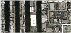
Roof Ads near Miami Airport (click to enlarge)
Now, most of the “roofvertisements” I could find were likely done with the intention of targeting promotional messages to airplane passengers, since most of the examples I can find are from buildings located near major airports. In happy serendipity for these companies, these ads are now also visible through the satellite images and aerial photos that have become table stakes for map search interfaces, so they’re getting dual use for them along with extra ad impressions. It’s pretty surprising to me that more companies haven’t painted promotional copy on their roofs, though, since I see tons of expansive, white roof “canvas” that would be ideal for this located near airports.
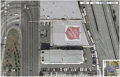
The Salvation Army in Seattle – (click to enlarge)
Click through for even more samples. (more…)
Possible Related Posts
Posted by Chris of Silvery on 08/30/2007
Permalink | | Print
| Trackback | Comments Off on Examples of Roof Ads | Comments RSS
Filed under: Advertising, Maps Advertisements, Advertising, Google-Maps, Guerilla-Advertising, Rooftop-Ads, Roofvertising, Satellite-Images
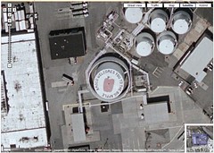
Factory Offers Up Rooftop Space for Ads
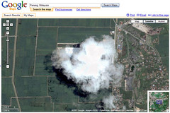
A company named Kumomo has issued a press release recently, announcing that it will sell rooftop ad space on one of Malaysia’s largest factories. Is this to be the first node in a network of roof billboard advertising space? The ads would be intended to be seen in Google Maps/Earth and via airplanes.
The rooftop ad would be installed by the California company, RoofAds, which specializes in painting logos and art onto the tops of buildings. Although Kumomo’s site and press release are vague about details on the roof in question, after considerable searching of satellite pics in Google Maps I was finally able to locate the location of the building where they’re intending to place the ad. Disconcertingly, the exact place is mostly obscured by clouds in the Google satellite pic, or perhaps it’s the factory’s own smoke:
Possible Related Posts
Posted by Chris of Silvery on 06/06/2007
Permalink | | Print
| Trackback | Comments Off on Factory Offers Up Rooftop Space for Ads | Comments RSS
Filed under: Advertising, Maps Google-Earth, Google-Maps, Kumomo, Roof-Ads, roof-advertising, Rooftop-Ads, Rooftop-Advertising, Roofvertising, Satellite-Images

