Google Street View Attacked As Potential Tool For Child Predators
The Stop Child Predators organization has launched a campaign specifically targeting Google’s Street View as a tool that potentially enables predators to stalk and kidnap children more effectively.

Kids playing at a park in Google Street View
A video on the site presents Stacie Runemap, Executive Director of the organization, outlining how Street View shows pictures of neighborhoods, homes, playgrounds, schools and pics of kids. She further describes how Google Maps can be used to plot distances from your doorstep to bus stops and schools, suggesting that child predators could use the service to plan attacks or kidnappings. The site elsewhere describes how to request that Google remove photos from Street View. (more…)
Possible Related Posts
Posted by Chris of Silvery on 07/23/2008
Permalink | |  Print
| Trackback | Comments (0) | Comments RSS
Print
| Trackback | Comments (0) | Comments RSS
Filed under: Google, Maps, Security Child Protection, Google Street View, Google-Maps, Internet Privacy, Internet Security, privacy
Google Maps Introduces User Review Snippets in Listings
The Google Lat Long Blog announced today that they’ve introduced little snippets of a user review with each business listing for which they have reviews data:
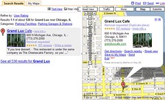
To me, this seems like a bit of an experimental feature, since I tend to want to see a sampling of multiple reviews to try to get a balanced picture of what to expect from a business. Of course, one can click through and view multiple reviews, but why would I only want to see one sample — is there something being done to try to select the most-typical review for the business, or are they only selecting random ones? (more…)
Possible Related Posts
Posted by Chris of Silvery on 06/10/2008
Permalink | | Print
| Trackback | Comments Off on Google Maps Introduces User Review Snippets in Listings | Comments RSS
Filed under: Google, Local Search, Maps directories, Google-Maps, User Reviews
Town Forces Google To Remove Pics From Street View
North Oaks, a small town in Minnesota, demanded that Google remove pictures of the town from Street View service.
The town apparently has a strong desire to remain private, and since most streets in it are privately owned, they threatened Google with trespassing citations if the pics weren’t removed.
I’m surprised they would attempt to use a trespassing citation for this, since it seems a little bit odd to have open streets for people to drive along, ungated, even with the “No Trespassing” signs. I would think a more viable claim would be copyright infringement since the town might claim that buildings or streets were marked as private, or if they charge some sort of entry fee for vehicles passing through. A similar claim is apparently possible if one takes photos of buildings/places for which admission fees are charged to see/enter — reselling such photos or making money off of them in some way is apparently actionable under copyright law.
Privacy groups have complained about Google Street View since it was introduced, and Google recently responded by initiating the use of software which blurs individuals’ faces in the streetview pics.
Possible Related Posts
Posted by Chris of Silvery on 06/02/2008
Permalink | | Print
| Trackback | Comments Off on Town Forces Google To Remove Pics From Street View | Comments RSS
Filed under: Google, Maps copyright infringement, Google, Google Street View, privacy issues
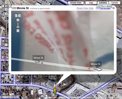
Interesting Sights To See In Google Street View
Be sure to check out my collection of cool sights in Street View over at Search Engine Land today.
While the piece is strictly fluffy, it does cover a wide range of pictures that illustrate why people are concerned about privacy with the utility along with why it’s cool and fun to have.
Here’s my favorite pic from the set – a photo that captured a bit of skywriting:

Possible Related Posts
Posted by Chris of Silvery on 05/29/2008
Permalink | | Print
| Trackback | Comments Off on Interesting Sights To See In Google Street View | Comments RSS
Filed under: Google, Maps candid photos, Google, Google Street View, internet photography
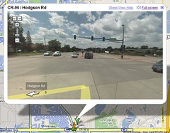
Opt Out of Google Street View?
The guys over at Google Sightseeing noticed that the Google Streetview camera in Fairbanks, Alaska apparently got covered over with plastic bags, obscuring some of the images that were shot.
This led to speculation that some enterprising residents had perhaps purposefully obscured the cameras out of privacy concerns – though, that seems moderately unlikely to me since I doubt most people know what the car even is when it’s tooling around, shooting photos of places. (more…)
Possible Related Posts
Posted by Chris of Silvery on 05/08/2008
Permalink | | Print
| Trackback | Comments Off on Opt Out of Google Street View? | Comments RSS
Filed under: Google, Maps Google-Maps, privacy, Street View, Surveillance
Will Geolocation Become Ubiquitous?
Chris Messina at Citizen Agency has just blogged about how he believes that geolocation data will become ubiquitous for websites to use, and this sort of contextual information about users will form a new layer of information that will available to all internet applications.
I find myself a bit skeptical, just because geolocation data has been around for so long now, and I’ve heard people saying that it will revolutionize how information is presented to us for quite some time. This concept is nothing new, though if you look at it from the perspective that Messina has provided, it’s a fairly compelling-feeling twist as a sort of infrastructure given that could and should be incorporated in the planning and development of any given internet site — particularly social ones — at their very inception.
What isn’t plain is just how integral all the locative information could be, considering the issues of unknowable error rates involved in geolocation data (see the section on “The issue of error rates” in “Geolocation: Core To The Local Space And Key To Click-Fraud Detection“) and consumer interest group resistance to pinpointing of users’ locations based upon privacy concerns (just today there was an article on how groups are complaining to the FTC about the ease of geo-pinpointing of users of mobile devices). I wish he’d touched on those aspects in some way, although I do like the techno-evangelist spin he’s provided on location as a foundational aspect in site design.
Update: Susan Mernit, formerly of Yahoo!, also points out that security is a major concern for applications like dating sites, and that there’s consumer irritation involved with some contextual advertising.
Possible Related Posts
Posted by Chris of Silvery on 05/06/2008
Permalink | | Print
| Trackback | Comments Off on Will Geolocation Become Ubiquitous? | Comments RSS
Filed under: Futurism, Local Search, Maps, Mobile Search geographic location, Geolocation, Local Search
Google Maps Now Allows Custom Categories For Businesses
Search Engine Roundtable notes that the Google Local Business Center is allowing businesses to enter their own, custom categories. While this new functionality has been around for a few weeks now, it is an important one and addresses a major need that both Mike Blumenthal and I have highlighted previously — I recently spoke about this issue again at the SMX West session on Local Search & Blended Results. Previously, businesses could only select business categories from an unusually short list of categories. Exacerbating the issue, some businesses achieved other category associations outside of Google’s sharply limited taxonomy when their listings found in other yellow pages providers such as Superpages were absorbed into Google Maps, including the more comprehensive categories found in those other content sources.
Under the new functionality, businesses may type in custom business categories, and the interface also provides helpful potential term using the Google Suggestion Tool:
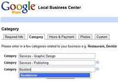
Free-form categories is a slightly unique way to address the need of businesses. Yellow pages companies have traditionally offered businesses the option of categorization under many thousands of unique categories — on the order of twelve thousand to fifteen thousand categories in some cases. However, YP companies have also carefully considered and turned down requests for additions of completely new categories in some cases, mainly due to how yellow pages are constructed — if there are too few businesses in a category it won’t make monetary sense to add it into a directory. And, if the category name is too esoteric, consumers won’t search for it anyway.
With Google’s local search operating more closely as a straight keyword search tool, businesses could associate categories with themselves that are as specific as they desire without affecting usability or cost.
In other, related news, Google has announced that YouTube videos are now integrated with Google Maps, allowing businesses to add video info to their listings.
Possible Related Posts
Posted by Chris of Silvery on 04/15/2008
Permalink | | Print
| Trackback | Comments Off on Google Maps Now Allows Custom Categories For Businesses | Comments RSS
Filed under: Google, Local Search, Maps, Online Directories, Searching, Yellow Pages
Where’s Waldo in Google Earth
In a very clever bit of marketing, Canadian artist Melanie Coles has created a large rooftop image of the iconic character found in the popular Where’s Waldo? book series.

The image is located somewhere in Vancouver, British Columbia, and was created with the specific intention of being findable via Google Earth (warning, I have the location pinpointed in a link and geocoordinates at the end of this post). It will be a while before Waldo can be found in Google Earth (or in Google Maps, Yahoo! Maps, or MS Live Search Maps, for that matter), because there is a time lag in between when satellite images and aerial photos get updated in those services — so, it could be six months to a year before the image is really findable and viewable online.
The image was created as a demonstration of a viral game for Coles’ graduation art project at the Emily Carr Institute. Her blog statement on the project says: (more…)
Possible Related Posts
Posted by Chris of Silvery on 04/14/2008
Permalink | | Print
| Trackback | Comments Off on Where’s Waldo in Google Earth | Comments RSS
Filed under: Google, Maps, News aerial-photos, Google-Earth, Google-Maps, Maps, Mapvertising, Roofvertising, Satellite-Images, Viral-Marketing, Where's Waldo
Google’s KML Becomes Industry Standard
 In an example of how becoming top dog can empower a company to influence and set industry-wide protocols, Google Earth’s KML format has been declared an open standard for geographical data by the Open Geospatial Consortium (“OGC”).
It’s really great and progressive that such a large, publicly-traded company such as Google would release control of its considerable intellectual property rights and allow KML to be used by anyone.
Google’s LatLong Blog also crows a bit about how KML is “the HTML of geographic content”, and explains that KML is no longer owned by Google, but is now administrated by the OGC.
Possible Related Posts
Posted by Chris of Silvery on 04/14/2008
Permalink | | Print
| Trackback | Comments Off on Google’s KML Becomes Industry Standard | Comments RSS
Filed under: Google, Local Search, Maps, technology Google-Earth, KML, open standards
Google Puts News On The Map
Google has partnered with the New York Times to put news on the map — the NYT has apparently begun geotagging their news stories so that Google can associate news items with particular locations around the world. The Google Earth application can now be used to browse around a map of the world, and headlines are associated with their places of origin.
Newspapers have been very fearful of the internet and have lost revenue from their print side to free internet alternatives. But, it’s clear that embracing greater integration with interactive technologies is one viable way to remain competitive.
Possible Related Posts
Posted by Chris of Silvery on 04/08/2008
Permalink | | Print
| Trackback | Comments Off on Google Puts News On The Map | Comments RSS
Filed under: Google, Maps, News Google-Earth, Maps, New York Times, Newspapers

