Los Angeles Times Google Map of California Fires
Every day it seems like someone else is using Google Maps for some interesting application, and today’s yet another example. The LA Times has put together a special map of the fires raging in California:
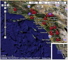
(click to enlarge) or (pan/zoom map)
Share-able online mapping systems like Google Maps have really empowered people to easily use geographic data in extraordinary ways.
Continue reading »Possible Related Posts
Posted by Chris of Silvery on 10/22/2007
Permalink | |  Print
| Trackback | Comments Off on Los Angeles Times Google Map of California Fires | Comments RSS
Print
| Trackback | Comments Off on Los Angeles Times Google Map of California Fires | Comments RSS
Filed under: Maps California-Fires, Google-Maps, LA-Wildfires, Los-Angeles-Fires, Los-Angeles-Times, Wildfires
Google Maps forces Navy to redesign swastika building
Quite some time back, I came across this Swastika-shaped building via Google Maps, and posted the screengrab in my Flickr account. Since then, it became one of my most popular Flickr pictures, since strange stuff like this can become quickly viral. Loads of people (16,000+) have viewed the photo’s page, and then various journalists contacted me and posted the photo on news stories in Europe and elsewhere. Here it is:
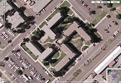
(click to view swastika photo profile page)
I researched the building and found it was a Navy building, apparently built unintentionally in the shape of a Nazi Swastika in California. This was built way before people anticipated the general public would be viewing buildings from the sky all that much, but now the easy accessibility of viewing satellite pics from Google Maps, Yahoo! Maps, Mapquest, Microsoft Live Maps, and other utilities have made birds-eye-viewing all too common. I photo-blogged the info I researched on the Flickr page, and quite a few people commented and favorited the unusual picture over time.
Today, CNN reported on the swastika building, and they added one really interesting new detail: (more…)
Possible Related Posts
Posted by Chris of Silvery on 09/26/2007
Permalink | | Print
| Trackback | Comments Off on Google Maps forces Navy to redesign swastika building | Comments RSS
Filed under: Google, Maps aerial-images, aerial-photos, Google-Maps, Mapquest, online-maps, Satellite-Images, Satellite-Photos, swastika-building, Yahoo!-Maps
Examples of Roof Ads
I thought it might be interesting to do a survey of roof ads from around the country, so here are a number of examples that can be found in online mapping systems such as Google Maps.
Roof Ad in New York City
If you recall, over a year ago I wrote a tongue-in-cheek post about how to optimize rooftop ads for best exposure in online maps, although some of the tips could actually be taken seriously if one did wish to market through advertising in this manner.
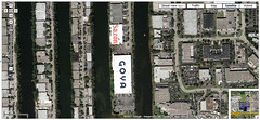
Roof Ads near Miami Airport (click to enlarge)
Now, most of the “roofvertisements” I could find were likely done with the intention of targeting promotional messages to airplane passengers, since most of the examples I can find are from buildings located near major airports. In happy serendipity for these companies, these ads are now also visible through the satellite images and aerial photos that have become table stakes for map search interfaces, so they’re getting dual use for them along with extra ad impressions. It’s pretty surprising to me that more companies haven’t painted promotional copy on their roofs, though, since I see tons of expansive, white roof “canvas” that would be ideal for this located near airports.
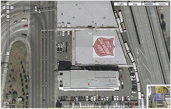
The Salvation Army in Seattle – (click to enlarge)
Click through for even more samples. (more…)
Possible Related Posts
Posted by Chris of Silvery on 08/30/2007
Permalink | | Print
| Trackback | Comments Off on Examples of Roof Ads | Comments RSS
Filed under: Advertising, Maps Advertisements, Advertising, Google-Maps, Guerilla-Advertising, Rooftop-Ads, Roofvertising, Satellite-Images
Google Maps adds Microformat support to results
I was pleased to see that Google Maps team announced support of the hCard microformat today in map search results. This will make the export of address/contact info easier for users, and pave the way for perhaps greater integration between the map results and other applications. If you have a browser with a Microformat plugin feature, you can easily export listing information for use in Outlook or other applications you may have:

Can we hope that Google’s support of Microformats at the front-end of their application might also indicate that they may eventually support Microformats at the back-end? As you may recall, in local SEO tips I posted last year, I recommended that local business webmasters not just include their business address on their site pages, but to do so in the hCard Microformat. I was probably the first to propose doing this for local search optimization, even though there’s been no overt mention from the search engine representatives that this is necessary or desirable. So, why did I recommend doing that?
Possible Related Posts
Posted by Chris of Silvery on 07/31/2007
Permalink | | Print
| Trackback | Comments Off on Google Maps adds Microformat support to results | Comments RSS
Filed under: Google, Local Search, Maps Google-Maps, microformats
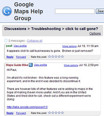
Google Quietly Decommissions Click-to-Call from Maps
Google quietly decommissioned their experimental click-to-call services from Google Maps. Previously, you could use the “call” links beside phone numbers in their search results:
It’d be nice if Google would officially mention when they remove such features from service, even if they were considered experimental. Quite a number of people reported using the feature, and some were even reliant upon it for making things like personal long-distance calls from within companies that didn’t allow employees to do so, or where long distance was actively blocked. Google didn’t announce the change on the Google LatLong Blog where you might expect, but instead stated it in a response to a user’s question in the Troubleshooting section of the Google Maps Help Group:
Of course, the service was introduced free, and no one can ever expect a free ride forever, and perhaps cell phones make click-to-call less attractive to users. Though, I would’ve expected they’d first see if they could get such a service to pay for itself through advertising before throwing it out altogether. For instance, each call could’ve been prepended by a brief audio ad or they could be displaying ads along side the call/maps interfaces while users were connecting through. Perhaps they just had trouble working out call quality issues.
For those users seeking a good voice-over-IP (“VOIP”) solution, I guess they can sign up for Skype.
Update: I see this has also been reported by Grant Robertson at downloadsquad.
Possible Related Posts
Posted by Chris of Silvery on 07/20/2007
Permalink | | Print
| Trackback | Comments Off on Google Quietly Decommissions Click-to-Call from Maps | Comments RSS
Filed under: Google, Maps Click-to-Call, Google-Maps, voip
Google Maps could be chocked full-O-ads
I was glancing at Google Maps of Tokyo when I noticed just how many ads they have running in them! I can see icons for all sorts of chain restaurants for instance, including: McDonald’s, Baskin-Robbins, 7-Eleven, Royal Host, Mini Stop, Taco John’s, Denny’s, KFC, ampm, etc.
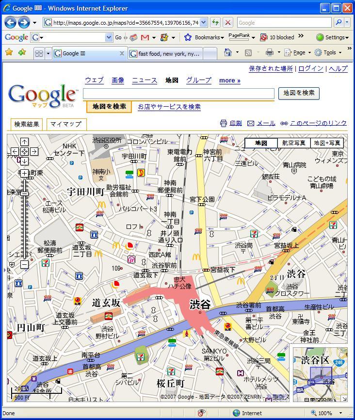
Now, we’ve already seen ads in Google Maps here in America, but in a much more limited deployment:

The Tokyo map ads are not clickable like the ads in the states.
What’s really different with the Tokyo map is the density of ads within the maps is much greater, and there seems to be much more variety of companies advertising. I can only see this as the likely future for Google Maps here in the US, too — more ads, from more companies.
UPDATE 3/18/2010: Mike Blumenthal reports on how icon ads have been added to Google Maps in Australia.
Possible Related Posts
Posted by Chris of Silvery on 06/20/2007
Permalink | | Print
| Trackback | Comments Off on Google Maps could be chocked full-O-ads | Comments RSS
Filed under: Google, Local Search, Maps Google-Maps, Google-Maps-Tokyo, Map-Ads, Map-Advertising
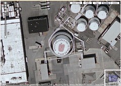
Factory Offers Up Rooftop Space for Ads
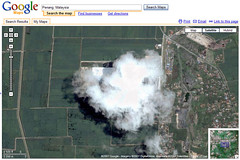
A company named Kumomo has issued a press release recently, announcing that it will sell rooftop ad space on one of Malaysia’s largest factories. Is this to be the first node in a network of roof billboard advertising space? The ads would be intended to be seen in Google Maps/Earth and via airplanes.
The rooftop ad would be installed by the California company, RoofAds, which specializes in painting logos and art onto the tops of buildings. Although Kumomo’s site and press release are vague about details on the roof in question, after considerable searching of satellite pics in Google Maps I was finally able to locate the location of the building where they’re intending to place the ad. Disconcertingly, the exact place is mostly obscured by clouds in the Google satellite pic, or perhaps it’s the factory’s own smoke:
Possible Related Posts
Posted by Chris of Silvery on 06/06/2007
Permalink | | Print
| Trackback | Comments Off on Factory Offers Up Rooftop Space for Ads | Comments RSS
Filed under: Advertising, Maps Google-Earth, Google-Maps, Kumomo, Roof-Ads, roof-advertising, Rooftop-Ads, Rooftop-Advertising, Roofvertising, Satellite-Images
“Roofvertising” mentioned in the news
Greg Sterling and I were quoted in a news story in yesterday’s USAToday by Craig Wilson in an article titled “Shout a message from the rooftops to the world“, along with Google Earth’s Chikai Ohazama. The article is about how people are increasingly trying to use Google Maps and other online mapping systems to communicate messages or display ads through them. People place the messages on rooftops or other ground surfaces which may be seen via the satellite pix or aerial photos in those interfaces.
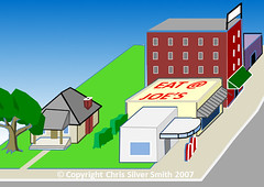
Rooftop Ads or “Roofvertising” is becoming more common
Possible Related Posts
Posted by Chris of Silvery on 06/05/2007
Permalink | | Print
| Trackback | Comments Off on “Roofvertising” mentioned in the news | Comments RSS
Filed under: Advertising, Maps, News Advertisements, Advertising, Google-Maps, marriage-proposals, roof-advertising, Rooftop-Ads, Roofvertising, Satellite-Photos
Plea for a New Open Format: Open Local Profile Format
My most-recent Locals Only column just pubbed at SearchEngineLand.com, titled “A Call To Standardize Local Search Listings“.

Open Local Profile Format
In it, I’m calling for the companies operating in the local search space to come together and agree upon a common data format protocol that would allow businesses and organizations to more easily submit their directory profile information to the great plethora of local info sites where users go to get information. The local search engines, online yellow pages, and various vertical directories should come together to reduce costs/complexity for businesses, and to facilitate improved information for consumers, similar to how the major search engines last year came together to agree on one common submission protocol – Sitemaps – for submitting sites’ page links to them. Read on for more details.
Possible Related Posts
Posted by Chris of Silvery on 06/04/2007
Permalink | | Print
| Trackback | Comments Off on Plea for a New Open Format: Open Local Profile Format | Comments RSS
Filed under: Local Search, Yellow Pages Business-Listings-Data, Google-Maps, hCard, microformats, Open-Formats, Open-Local-Profile, Open-Local-Profile-Format, Sitemaps, Yahoo-Local, Yellow Pages
Google Map API to Now Include Ads
InfoWorld reports that at a conference yesterday, Google Maps engineer Andrew Eland announced that Google has integrated its AdSense program with Google Maps so that those using their Maps API and developer tools would be able to derive money off the clickthroughs to the map ads when displayed on their site pages.

Detail – Google Map Ads
Possible Related Posts
Posted by Chris of Silvery on 06/01/2007
Permalink | | Print
| Trackback | Comments Off on Google Map API to Now Include Ads | Comments RSS
Filed under: Advertising, Google, Local Search, Maps AdSense, Affiliate Marketing, Google, Google-Maps, Map-APIs, Mapping

